South Dakota Mystery: Turns Out It IS a Bomb Target
There's been a new development in the story of a mystery 2,000-foot formation in Western South Dakota.
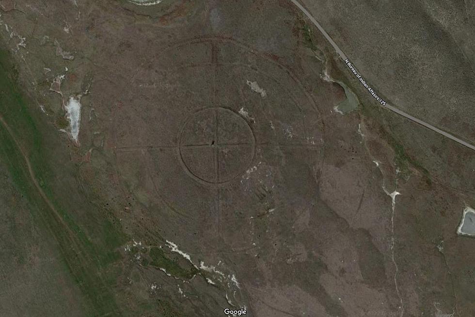
After the image of the bulls-eye-shaped plot of land was splashed all over social media last week, people have been trying to figure out exactly what it is.

It all began with a Reddit post from user u/patchesandbrownie who claimed to have found they believed was a 'bomb target' in western South Dakota.
The plot of land in question is situated between Badlands National Park and the banks of the White River, about 24 miles southwest of Wall.
MYSTERY: Is There a Massive Bomb Target in Western South Dakota?
The mystery was picked up by media outlets worldwide, including the British newspaper The Daily Star.
The guesses began pouring in quickly on social media: nuclear testing, calibrating targeting systems for weapons, or something associated with the space program.
Earlier this week, a promising lead came from a comment on Newsbreak about the site's resemblance to a Native American Medicine Wheel, similar to this one in the Bighorn National Forest in North Central Wyoming, just South of the Montana border.
WHAT IS IT: Is South Dakota’s ‘Bomb Target’ Actually a Medicine Wheel?

But now we may have a definitive answer thanks to another social media comment.
On the B1027 Facebook page, listener Emily Hohenthaner Radech shared the link to a Wikipedia page devoted to the Badlands Bombing Range.
According to the page, the range covers 341,726 acres of land federally acquired in 1942 under eminent domain on the Pine Ridge Indian Reservation.
Over the years, the range has been used for bomb targeting by World War II aircraft, and later as an Army National Guard gunnery range and a Cold War Radar Bomb Scoring site.
As for the specific parcel of land in question, it's known as the Interior Radar Bomb Scoring Site, which was established in 1960 on a location called Hurley Butte.
Its satellite coordinates (43.719846°N 102.14294°W) put it just 10 miles Northeast from the site of the mysterious bulls-eye shaped land, at 43°39'17"N 102°19'55"W.

Considering that 341,726 acres translate to roughly 534 square miles, that seems to settle the debate.
For now...
TRENDING FROM RESULTS-TOWNSQUARE MEDIA SIOUX FALLS:
- Is There a Massive Bomb Target in Western South Dakota?
- Minnesota Man Arrested After Ramming His Car Into His Own House
- South Dakota Truck Stop Fuel Pumps Will Soon Need Updating
- 10 South Dakota Restaurants That Are TV Famous
15 Ways You Can Help People in Ukraine Right Now
Gallery Credit: Traci Taylor
LOOK: Food history from the year you were born
Gallery Credit: Joni Sweet
LOOK: Things from the year you were born that don't exist anymore
Gallery Credit: Stacey Marcus
More From KKRC-FM / 97.3 KKRC