“Winter Storm Warning” Issued For Minnesota, Iowa, & South Dakota
A “Winter Storm Warning” could bring heavy snow and gusty winds to portions of Minnesota, Iowa, and South Dakota.
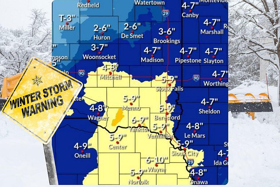
According to the National Weather Service in Sioux Falls Winter Storm Warnings and Winter Weather Advisories will cover the majority of the Minnesota, Iowa, and South Dakota tri-state region through Tuesday morning.
A WINTER STORM WARNING is in effect from 12 Midnight Sunday until 6 a.m. Tuesday.
* WHAT...Heavy snow expected. Total snow accumulations of 6 to 11
inches.
* WHERE...In Iowa, Lyon County. In Minnesota, Rock County. In
South Dakota, Minnehaha and Lincoln Counties.
* WHEN...From midnight tonight to 6 AM CST Tuesday.
* IMPACTS...Travel could be very difficult. The hazardous conditions could impact the morning and evening commute.
Monday will see snow expand across the Minnesota, Iowa, and South Dakota tri-state region with a widespread with up to 11 inches of snow possible.
Areas near and south of I-90 and near and west of I-29 will likely see amounts in the 6 to 9 inch range.
The more impactful snow will shift east of the area late Monday night and Tuesday morning.
Some blowing snow will be possible with the better chances in areas with the heaviest snow.
You Won't Believe The List Of Minnesota's 8 Deadliest Animals
More From KKRC-FM / 97.3 KKRC